Geohazard Supersites
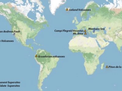
Most SAR satellites need to be tasked for specific targets. To ensure the SAR data acquisition for geohazard sites, the Group on Earth Observations (GEO) established the Geohazard Supersites and Natural Laboratory initiative (GSNL). It provides both, multi-sensor SAR and in-situ observations (GPS and seismic) for the selected sites. Permanent Supersites include the Hawaiian and the Icelandic volcanoes. The GSNL also provides imagery for earthquake and volcanic disasters (so-called “event Supersites”). Falk Amelung helped to get this initiative started as the previous Chair and we now use these data for our research. Click here for more information.